Invasive Phragmites (Phragmites australis) is a growing threat to the Greater Sudbury region as it continues to spread northward from southern Ontario. This aggressive reed forms dense stands that outcompete native vegetation, reduce biodiversity, alter wetland habitats, and negatively impact wildlife. Greater Sudbury's extensive network of more than 330 lakes, rivers, and streams increases the risk of spread, as seeds and plant fragments can be carried long distances by water. The region's industrial legacy and disturbed landscapes may also provide favourable conditions for establishment, while the municipality's vast area of more than 3,000 square kilometres makes comprehensive monitoring both challenging and essential.
Managing invasive Phragmites in Greater Sudbury is further complicated by the presence of both native and invasive subspecies. Accurate identification is critical to ensure that management efforts target only invasive populations while protecting native stands. Through early detection, ongoing monitoring, and rapid response, we can help prevent the spread of invasive Phragmites and protect the health of our wetlands and waterways.
Reporting Phragmites is essential for tracking its distribution and spread throughout Greater Sudbury. These reports help identify priority areas for monitoring and management, supporting more effective control efforts and protecting local ecosystems. Sightings of invasive species can be reported through EDDMapS.org or iNaturalist.ca, both of which offer free mobile apps for smart devices.
Resources
Learn more about invasive Phragmites and how to stop the spread.
- Invasive Species Centre
- Ontario Phragmites Action
- Ontario Invasive Plant Council
- Great Lakes Phragmites Collaborative
- Stop the Spread Handout – By the Lake
- Stop the Spread Handout – Hunters & Anglers
- Stop the Spread Handout – Snowmobilers
Phragmites in Sudbury
Invasive Phragmites (Phragmites australis) is a growing concern in the Sudbury region as it is on the forefront of encroaching spread from southern reaches. Greater Sudbury poses unique challenges for the spread and control of invasive Phragmites. There are over 330 lakes and a network of rivers and streams which increases the risk of Phragmites spreading since the seeds can easily travel long distances in flowing water. Phragmites has also been reported in heavily polluted areas such as those that contain mining waste and metals that kill most native species but provide adequate growing conditions for Phragmites with little to no competition. This may result in higher occurrences in the region since Sudbury is one of the largest mining communities in North America and has mining facilities situated at the headwaters of Junction Creek and its tributaries.
Comprehensive mapping is critical for defining the scope of invasive species spread and identifying priority sites. Greater Sudbury is over 3,000 square kilometres in area, requiring greater efforts in species monitoring to cover such a large geographic area to fully understand the extent of spread in the region. Sharing knowledge and resources are effective ways to amplify monitoring efforts, however, there is currently no regional level planning for invasive Phragmites in Greater Sudbury. Consequently, much of Greater Sudbury remains unmapped despite past community efforts. Therefore, there is a strong need for targeted invasive Phragmites monitoring and collaborative planning in Sudbury for long-term management and prevention.
Phragmites Patrol: Monitoring and Controlling Invasive Phragmites Project
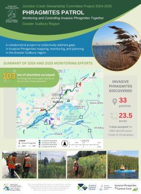
In 2024, the Junction Creek Stewardship Committee (JCSC) launched the Phragmites Patrol: Monitoring and Controlling Invasive Phragmites Togetherproject to collectively address gaps in mapping, monitoring, and managing invasive Phragmites australis (European Common Reed) in the Greater Sudbury region.
Key Activities and Results
- Mapping and Data Collection
We conducted extensive surveys along 81 km of shorelines in the upper reaches of Junction Creek watershed and surrounding lakes, filling important data gaps for comprehensive mapping and to support regional Phragmites management efforts. We also collected DNA samples to distinguish between native and invasive subspecies. - Public Engagement
Throughout the project, we provided applied learning opportunities for students, informative presentations and outreach material, and encouraged community science involvement in invasive species reporting. We also hosted a free public information session featuring guest speakers and outreach displays to raise awareness about invasive Phragmites. - Collaborative Planning
The project facilitated collaboration with local partners and stakeholders to help create a coordinated regional approach for monitoring, prevention, and control of invasive Phragmites.
Learn more about invasive Phragmites:
- Phragmites - Ontario Invasive Plant Council
- Great Lakes Phragmites Collaborative | Linking people, information & action
- Invasive Phragmites | Ontario's Invading Species Awareness Program
- Invasive Phragmites – Profile and Resources | Invasive Species Centre
This project is made possible with the support of the Ontario Phragmites Action program and supporting funder, the Ontario Ministry of Natural Resources. The views expressed are solely the views of JCSC and do not necessarily reflect those of the Province, Ministry of Natural Resources or the Invasive Species Centre.